Pict. [Mapporn] Ethnic proportions in Russian Federation's autonomous republics (based on 1989 census)[1,993px (#Russian #Based #Ethnic #Proportions #Republics #993px)Pict. 1993×1381 px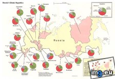 Pict. [Mapporn] [OC] % of US Households Obtaining Food Stamps By Census Tract. [Source 2012 5 Year American Community Survey] [1907x86 (#Year #Source #American #Food #Tract #Households #Obtaining)Pict. 1907×869 px
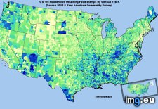 Pict. [Mapporn] 'Peoples of Yugoslavia distribution by opština' from official 1981 CIA census data [4595x2956] (#Data #Distribution #Tina #Cia #Peoples #Yugoslavia)Pict. 2757×1774 px
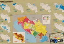 Pict. [Mapporn] First Census Year in Which 50% of Current Population Level Attained (US States & Canadian Provinces) [1200x778] (#Year #States #Population #Census #Provinces)Pict. 1200×778 px
 Pict. [Mapporn] [OC] % of English Speaking Only [Age 5 up] By US Census Tract [2012 5 Year American Community Survey] [1668x839] (#Year #American #English #Community #Speaking #Tract)Pict. 1668×839 px
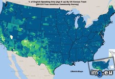 Pict. [Mapporn] Majority ethnicity by DS Division according 2012 census in Sri Lanka [640x1009] (#Census #Division #Sri #Ethnicity #640x1009)Pict. 640×1009 px
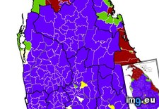 Pict. [Mapporn] Proportion of respondents who said they could speak Irish in the Ireland census 2011 and the Northern Ireland census 2 (#Northern #Ireland #Speak #Proportion #Respondents)Pict. 2000×2788 px
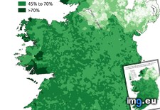 GIF [Mapporn] 10.8% of US Population [25+] has a Graduate or Professional Degree-Here is where they are by Census Tract-State [1920 (#State #Population #Professional #Tract #Graduate)GIF 1920×1080 px
 Pict. [Mapporn] Map of Canada indicating the Territory Occupied by each Aboriginal Group, Census of Canada, 1870-71. [900×564] (#Map #Canada #Group #Aboriginal #Indicating)Pict. 900×564 px
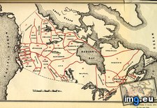 GIF [Mapporn] Languages [other than english] Used in the Home by USA state-census tract [1798x928] [GIF] (#Gif #State #Languages #Census #Tract)GIF 1798×928 px
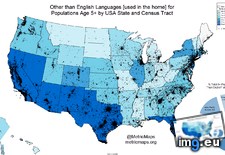 Pict. [Mapporn] 13.9% of US Population [Age 25+] is without a High School Diploma [or Equivalent]. Here is where they are by Census T (#High #School #Census #Equivalent #Diploma)Pict. 1893×920 px
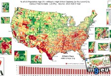 Pict. [Mapporn] Population change of every Norwegian Municipality from 2002 to 2012 (using census estimates) [1320x1025] OC (#Change #Population #Norwegian #Census #Municipality)Pict. 1320×1025 px
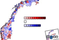 Pict. [Mapporn] Religion in the Kingdom of SHS(Yugoslavia) According to 1921 Census [800x728] (#Kingdom #Census #Religion #Yugoslavia #800x728 #Shs)Pict. 800×728 px
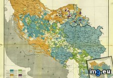 Pict. [Mapporn] Most common surnames in England & Wales from the 1881 census. [2,195px × 1,905px] (#England #Common #Wales #Census #Surnames #905px)Pict. 2195×1905 px
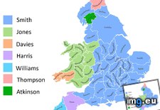 Pict. [Mapporn] Population Density of New Zealand by Census Mesh Block [3937x4330] (#Population #Zealand #Density #Census #Mesh)Pict. 3937×4330 px
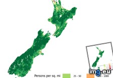 Pict. [Mapporn] Leading Minority Group by County (2000 Census) [960x680] (#Group #County #Census #Leading #Minority #960x680)Pict. 960×680 px
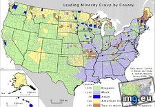 Pict. [Mapporn] US map of census blocks with 0 population - 47% are empty [990x1148] (#Map #Cumming #Population #Empty #Blocks #Census)Pict. 990×1148 px
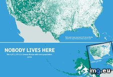 Pict. [Mapporn] Population Density of Washington State by Census Block [3507x2480] (#State #Population #Washington #Density #Census)Pict. 3507×2480 px
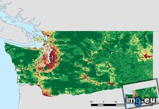 Pict. [Mapporn] Most common surnames in Scotland from the 1881 census. [OC][1,479px × 1,688px] (#Scotland #Common #Census #Surnames #688px)Pict. 1479×1688 px
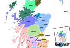 Pict. [Mapporn] New York City median income by census block group. (1584x1109) (#City #Group #York #Income #Census #Median)Pict. 1584×1109 px
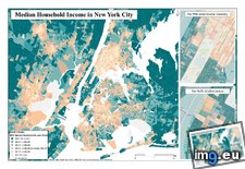 Pict. [Mapporn] Largest % of Jobs by Industry Type by [US Census Tract] [1885x898] (#Largest #Type #Jobs #Census #Industry #Tract)Pict. 1885×898 px
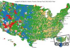 Pict. [Mapporn] Map with a dot representing every person counted by the 2010 US census [4776x2592] (#Map #Person #Dot #Census #Representing #Counted)Pict. 4776×2592 px
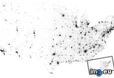 Pict. [Mapporn] Population Density of Kansas by Census Block [3156x2232] (#Population #Density #Census #Kansas)Pict. 3156×2232 px
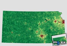 Pict. [Mapporn] Population Density of Florida by Census Block [3507x2480] (#Population #Florida #Density #Census)Pict. 3507×2480 px
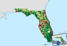
★ 7940 pts. ♥ 0 likes ⬇ 6 saves
Pict. [Mapporn] [OC] % of US Households Obtaining Food Stamps By Census Tract. [Source 2012 5 Year American Community Survey] [1907x86 (#Year #Source #American #Food #Tract #Households #Obtaining)Pict. 1907×869 px★ 7750 pts. ♥ 0 likes ⬇ 2 saves
Pict. [Mapporn] 'Peoples of Yugoslavia distribution by opština' from official 1981 CIA census data [4595x2956] (#Data #Distribution #Tina #Cia #Peoples #Yugoslavia)Pict. 2757×1774 px★ 7243 pts. ♥ 0 likes ⬇ 13 saves
Pict. [Mapporn] First Census Year in Which 50% of Current Population Level Attained (US States & Canadian Provinces) [1200x778] (#Year #States #Population #Census #Provinces)Pict. 1200×778 px★ 7108 pts. ♥ 0 likes ⬇ 8 saves
Pict. [Mapporn] [OC] % of English Speaking Only [Age 5 up] By US Census Tract [2012 5 Year American Community Survey] [1668x839] (#Year #American #English #Community #Speaking #Tract)Pict. 1668×839 px★ 6951 pts. ♥ 0 likes ⬇ 4 saves
Pict. [Mapporn] Majority ethnicity by DS Division according 2012 census in Sri Lanka [640x1009] (#Census #Division #Sri #Ethnicity #640x1009)Pict. 640×1009 px★ 6844 pts. ♥ 0 likes ⬇ 10 saves
Pict. [Mapporn] Proportion of respondents who said they could speak Irish in the Ireland census 2011 and the Northern Ireland census 2 (#Northern #Ireland #Speak #Proportion #Respondents)Pict. 2000×2788 px★ 6809 pts. ♥ 0 likes ⬇ 10 saves
GIF [Mapporn] 10.8% of US Population [25+] has a Graduate or Professional Degree-Here is where they are by Census Tract-State [1920 (#State #Population #Professional #Tract #Graduate)GIF 1920×1080 px★ 6807 pts. ♥ 0 likes ⬇ 4 saves
Pict. [Mapporn] Map of Canada indicating the Territory Occupied by each Aboriginal Group, Census of Canada, 1870-71. [900×564] (#Map #Canada #Group #Aboriginal #Indicating)Pict. 900×564 px★ 6796 pts. ♥ 0 likes ⬇ 16 saves
GIF [Mapporn] Languages [other than english] Used in the Home by USA state-census tract [1798x928] [GIF] (#Gif #State #Languages #Census #Tract)GIF 1798×928 px★ 6491 pts. ♥ 0 likes ⬇ 8 saves
Pict. [Mapporn] 13.9% of US Population [Age 25+] is without a High School Diploma [or Equivalent]. Here is where they are by Census T (#High #School #Census #Equivalent #Diploma)Pict. 1893×920 px★ 6414 pts. ♥ 0 likes ⬇ 7 saves
Pict. [Mapporn] Population change of every Norwegian Municipality from 2002 to 2012 (using census estimates) [1320x1025] OC (#Change #Population #Norwegian #Census #Municipality)Pict. 1320×1025 px★ 6369 pts. ♥ 0 likes ⬇ 9 saves
Pict. [Mapporn] Religion in the Kingdom of SHS(Yugoslavia) According to 1921 Census [800x728] (#Kingdom #Census #Religion #Yugoslavia #800x728 #Shs)Pict. 800×728 px★ 6123 pts. ♥ 0 likes ⬇ 6 saves
Pict. [Mapporn] Most common surnames in England & Wales from the 1881 census. [2,195px × 1,905px] (#England #Common #Wales #Census #Surnames #905px)Pict. 2195×1905 px★ 6001 pts. ♥ 0 likes ⬇ 8 saves
Pict. [Mapporn] Population Density of New Zealand by Census Mesh Block [3937x4330] (#Population #Zealand #Density #Census #Mesh)Pict. 3937×4330 px★ 5906 pts. ♥ 0 likes ⬇ 7 saves
Pict. [Mapporn] Leading Minority Group by County (2000 Census) [960x680] (#Group #County #Census #Leading #Minority #960x680)Pict. 960×680 px★ 5854 pts. ♥ 0 likes ⬇ 5 saves
Pict. [Mapporn] US map of census blocks with 0 population - 47% are empty [990x1148] (#Map #Cumming #Population #Empty #Blocks #Census)Pict. 990×1148 px★ 5844 pts. ♥ 0 likes ⬇ 4 saves
Pict. [Mapporn] Population Density of Washington State by Census Block [3507x2480] (#State #Population #Washington #Density #Census)Pict. 3507×2480 px★ 5807 pts. ♥ 0 likes ⬇ 2 saves
Pict. [Mapporn] Most common surnames in Scotland from the 1881 census. [OC][1,479px × 1,688px] (#Scotland #Common #Census #Surnames #688px)Pict. 1479×1688 px★ 5802 pts. ♥ 0 likes ⬇ 8 saves
Pict. [Mapporn] New York City median income by census block group. (1584x1109) (#City #Group #York #Income #Census #Median)Pict. 1584×1109 px★ 5786 pts. ♥ 0 likes ⬇ 8 saves
Pict. [Mapporn] Largest % of Jobs by Industry Type by [US Census Tract] [1885x898] (#Largest #Type #Jobs #Census #Industry #Tract)Pict. 1885×898 px★ 5722 pts. ♥ 0 likes ⬇ 8 saves
Pict. [Mapporn] Map with a dot representing every person counted by the 2010 US census [4776x2592] (#Map #Person #Dot #Census #Representing #Counted)Pict. 4776×2592 px★ 5612 pts. ♥ 0 likes ⬇ 4 saves
Pict. [Mapporn] Population Density of Kansas by Census Block [3156x2232] (#Population #Density #Census #Kansas)Pict. 3156×2232 px★ 5415 pts. ♥ 0 likes ⬇ 4 saves
Pict. [Mapporn] Population Density of Florida by Census Block [3507x2480] (#Population #Florida #Density #Census)Pict. 3507×2480 px★ 5368 pts. ♥ 0 likes ⬇ 6 saves