★ 8403 pts. ♥ 0 likes ⬇ 14 saves
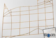
 Pict. [Mapporn] Rebbilib, a traditional Polynesian stick chart used for ocean navigation, circa 1900, Marshall Islands. [837×768] (#Ocean #Islands #Stick #Marshall #Polynesian #Navigation #Rebbilib)Pict. 837×768 px
★ 8356 pts. ♥ 0 likes ⬇ 10 saves
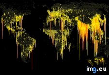
 Pict. [Mapporn] Human ooze: World population density by latitude-longitude, with traditional chart axis flipped [OC] [1500x765] (#World #Population #Human #Density #Latitude #Longitude #Ooze)Pict. 1500×765 px
★ 8226 pts. ♥ 0 likes ⬇ 6 saves
 Pict. Chart.apis.google.com Chart?chf=bg,s,ffffff Chs=380x380 Cht=qr Chld=|1 Chl=https 3a 2f 2fwww.youtube (#Com #Google #Chart #Youtube #Chs #Cht #Ffffff #2fwww)Pict. 380×380 px
★ 7803 pts. ♥ 0 likes ⬇ 17 saves
 Pict. Chart.googleapis.com Chart?chf=bg,s,ffffff Chs=380x380 Cht=qr Chld=|1 Chl=http 3a 2f 2fwww.aloshbennett (#Com #Chart #Chl #Chf #2fwww #Aloshbennett #Googleapis)Pict. 380×380 px
★ 7471 pts. ♥ 0 likes ⬇ 17 saves
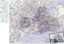
 Pict. [Mapporn] Helicopter Route Chart and location of Heliports, New York City region, circa 1988. [2000×1259] (#City #York #Route #Location #Helicopter #Heliports)Pict. 2000×1259 px
★ 7298 pts. ♥ 0 likes ⬇ 8 saves
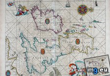
 Pict. [Mapporn] Nautical chart of Paros and Antiparos in the Aegean sea, from a Venetian maritime atlas printed ca. 1485 [1086x1121] (#Sea #Chart #Maritime #Nautical #Venetian)Pict. 1086×1121 px
★ 6801 pts. ♥ 0 likes ⬇ 10 saves
 Pict. [Mapporn] Manuscript Japanese Chart -southern coast to Ogasawara islands(?) 2730 x 3666 (#Japanese #Coast #Chart #Manuscript #Ogasawara)Pict. 2730×3666 px
★ 6728 pts. ♥ 0 likes ⬇ 8 saves
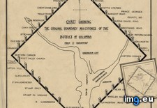
 Pict. [Mapporn] Chart showing the original boundary milestones of the District of Columbia [1934x2218] (#Showing #Original #Chart #Boundary #Milestones)Pict. 1934×2218 px
★ 6614 pts. ♥ 0 likes ⬇ 12 saves
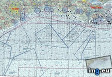
 Pict. [Mapporn] Gulf of Mexico chart used by pilots in the Oil industry. Each black dot is an oil well or platform. [2250x1130] (#Black #Mexico #Oil #Industry #Platform #Pilots)Pict. 2250×1130 px
★ 6570 pts. ♥ 0 likes ⬇ 16 saves
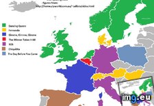
 Pict. [Mapporn] Abba single with longest chart run in European countries [1340x1256] [OC] (#European #Countries #Chart #Longest #Abba)Pict. 1340×1256 px
★ 6562 pts. ♥ 0 likes ⬇ 10 saves
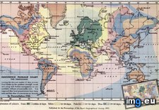
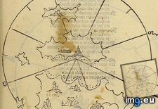
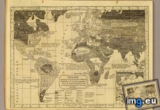
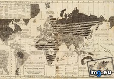
 Pict. [Mapporn] Chart of the Inhabited World: Exhibiting the Prevailing Religion, Form of Government, Degree of Civilization, & Po (#World #Form #Degree #Religion #Civilization)Pict. 5478×4192 px
★ 6525 pts. ♥ 0 likes ⬇ 5 saves
 Pict. Female Body Types Chart (#Body #Female #Chart #Types)Pict. 874×914 px
★ 6508 pts. ♥ 0 likes ⬇ 9 saves
 Pict. Chart.apis.google.com Chart?chf=bg,s,ffffff Chs=380x380 Cht=qr Chld=|1 Chl=http 3a 2f 2flink (#Com #Google #Chart #Chld #Chs #Cht #Ffffff)Pict. 380×380 px
★ 6361 pts. ♥ 0 likes ⬇ 10 saves
 Pict. Chart.apis.google.com Chart?chf=bg,s,ffffff Chs=380x380 Cht=qr Chld=|1 Chl=http 3a 2f 2fkinozal (#Com #Google #Chart #Chld #Chs #Cht #Ffffff)Pict. 380×380 px
★ 6202 pts. ♥ 0 likes ⬇ 12 saves
 Pict. Chart.apis.google.com Chart?chf=bg,s,ffffff Chs=380x380 Cht=qr Chld=|1 Chl=http 3a 2f 2fwhoer (#Com #Google #Chart #Chld #Chs #Cht #Ffffff)Pict. 380×380 px
★ 6115 pts. ♥ 0 likes ⬇ 13 saves
 Pict. [Mapporn] A Detailed Navigation Chart Of The Narrow Seas from 1672 - By John Seller, The King's Hydrographer [4061x3384] (#King #John #Chart #Detailed #Narrow #Seller)Pict. 4061×3384 px
★ 6101 pts. ♥ 0 likes ⬇ 9 saves
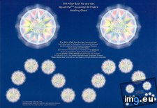
 Pict. Allur-e'ah Ra-sha-tan Axiatonal Chart - 1963x1378px (#Tan #Chart #Sha #Allur #Axiatonal)Pict. 1239×870 px
★ 5503 pts. ♥ 0 likes ⬇ 10 saves
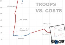
 Pict. [Dataisbeautiful] Chart redraw: Troops Vs. Cost from 1980-2012 (Time Magazine) [ Or, a clean dataset with two 'beautiful' interp (#Time #Two #Beautiful #Magazine #Troops #Dataset #Interp)Pict. 969×1053 px
★ 5181 pts. ♥ 0 likes ⬇ 9 saves
 Pict. [Mapporn] [OS] Moral & political chart of the inhabited world (1821)[5609x3479] (#World #Chart #Political #Moral)Pict. 5609×3479 px
★ 5155 pts. ♥ 0 likes ⬇ 4 saves
 Pict. [Mapporn] Portolan chart by Jorge de Aguiar (1492) (5,016 (#Chart #Jorge #Aguiar #Portolan)Pict. 2508×1939 px
★ 5130 pts. ♥ 0 likes ⬇ 4 saves
★ 5115 pts. ♥ 0 likes ⬇ 12 saves
 Pict. Chart.apis.google (#Google #Chart #Apis)Pict. 380×380 px
★ 4443 pts. ♥ 0 likes ⬇ 8 saves
 Pict. [Mapporn] Lunar Earthside Chart [6105x4277] (#Chart #Lunar )Pict. 6105×4277 px
★ 4404 pts. ♥ 0 likes ⬇ 8 saves
