Pict. [Earthporn] Photograph of Pitamakan lake taken near the Continental Divide Trail. Glacier National Park, MT [OC] [2764x2073] (#Park #National #Lake #Continental #Divide #2764x2073 #Pitamakan)Pict. 2764×2073 px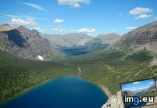 Pict. [Earthporn] Craggy peaks and alpine tundra of the Colorado Rockies from the Continental Divide [4637x2871] (#Colorado #Peaks #Continental #Divide #Tundra)Pict. 4637×2871 px
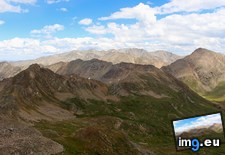 Pict. [Earthporn] A trail running through the continental divide at Þingvellir, Iceland [oc][2579 x 1449] (#Iceland #Trail #Running #Continental #Divide #Ingvellir)Pict. 2579×1449 px
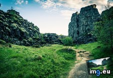 Pict. [Earthporn] Continental Divide, Weminuche wilderness, CO [2707x1800] (#Wilderness #Continental #Divide #2707x1800 #Weminuche)Pict. 2707×1800 px
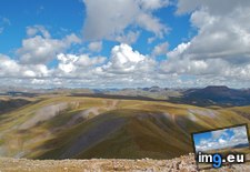 Pict. [Mapporn] Future World: Prediction of continental arrangements 50 million years from now based on present-day tectonic plate mot (#Day #Years #World #Based #Plate #Continental)Pict. 720×480 px
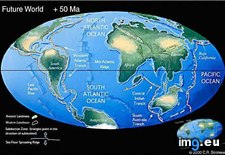 Pict. [Mapporn] Distribution of the term route by region in the continental US. [954X600] (#Distribution #Route #Region #Continental #Term #954x600)Pict. 954×600 px
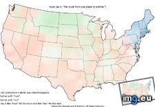 Pict. [Mapporn] Daily mean temperature anomaly in February in the continental U.S. [968x610] (#Daily #Temperature #February #Continental)Pict. 968×610 px
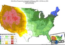 Pict. [Mapporn] Most televised NFL teams in different parts of the continental United States, 2009-2014 [1024x772] (#Parts #States #United #Nfl #Teams #Continental)Pict. 1024×772 px
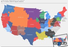 Pict. [Mapporn] Continental US Topographical Map [1549x960] (#Map #Continental #Topographical)Pict. 1549×960 px
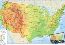 Pict. [Mapporn] Size comparison between the continental US and Brazil. [1600x1122] (#Size #Brazil #Comparison #Continental)Pict. 1024×719 px
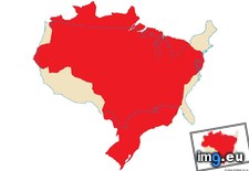 Pict. [Mapporn] Every Bus and Amtrak Route in the Continental US [5397 x 3036] (#Bus #Route #Continental #Amtrak)Pict. 5397×3036 px
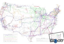 Pict. [Mapporn] Another County Map of the Continental USA [802 × 535][OC] (#Map #County #Usa #Continental)Pict. 802×535 px
 Pict. [Mapporn] Continental poles of inaccessibility [960x960] (#960x960 #Continental #Poles)Pict. 960×960 px
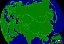 GIF [Dataisbeautiful] The shortest path through the 48 continental state capitals (animated) - Driving edition [OC] (#Animated #State #Edition #Continental #Capitals)GIF 1200×850 px
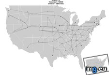 GIF [Dataisbeautiful] The shortest path through the 48 continental state capitals (animated) (#Animated #State #Path #Shortest #Continental #Capitals)GIF 640×640 px
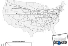 Pict. [Mildlyinteresting] Pothole in the parking lot at my work looks like the continental United States. (#Work #Lot #Parking #Continental #Pothole)Pict. 3107×1984 px
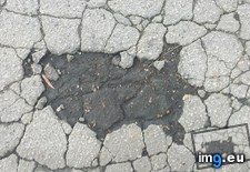
★ 342k pts. ♥ 0 likes ⬇ 10 saves
Pict. [Earthporn] Craggy peaks and alpine tundra of the Colorado Rockies from the Continental Divide [4637x2871] (#Colorado #Peaks #Continental #Divide #Tundra)Pict. 4637×2871 px★ 340k pts. ♥ 0 likes ⬇ 9 saves
Pict. [Earthporn] A trail running through the continental divide at Þingvellir, Iceland [oc][2579 x 1449] (#Iceland #Trail #Running #Continental #Divide #Ingvellir)Pict. 2579×1449 px★ 340k pts. ♥ 0 likes ⬇ 8 saves
Pict. [Earthporn] Continental Divide, Weminuche wilderness, CO [2707x1800] (#Wilderness #Continental #Divide #2707x1800 #Weminuche)Pict. 2707×1800 px★ 340k pts. ♥ 0 likes ⬇ 3 saves
Pict. [Mapporn] Future World: Prediction of continental arrangements 50 million years from now based on present-day tectonic plate mot (#Day #Years #World #Based #Plate #Continental)Pict. 720×480 px★ 7231 pts. ♥ 0 likes ⬇ 10 saves
Pict. [Mapporn] Distribution of the term route by region in the continental US. [954X600] (#Distribution #Route #Region #Continental #Term #954x600)Pict. 954×600 px★ 6309 pts. ♥ 0 likes ⬇ 6 saves
Pict. [Mapporn] Daily mean temperature anomaly in February in the continental U.S. [968x610] (#Daily #Temperature #February #Continental)Pict. 968×610 px★ 5687 pts. ♥ 0 likes ⬇ 4 saves
Pict. [Mapporn] Most televised NFL teams in different parts of the continental United States, 2009-2014 [1024x772] (#Parts #States #United #Nfl #Teams #Continental)Pict. 1024×772 px★ 5657 pts. ♥ 0 likes ⬇ 4 saves
Pict. [Mapporn] Continental US Topographical Map [1549x960] (#Map #Continental #Topographical)Pict. 1549×960 px★ 5565 pts. ♥ 0 likes ⬇ 8 saves
Pict. [Mapporn] Size comparison between the continental US and Brazil. [1600x1122] (#Size #Brazil #Comparison #Continental)Pict. 1024×719 px★ 5369 pts. ♥ 0 likes ⬇ 4 saves
Pict. [Mapporn] Every Bus and Amtrak Route in the Continental US [5397 x 3036] (#Bus #Route #Continental #Amtrak)Pict. 5397×3036 px★ 4961 pts. ♥ 0 likes ⬇ 4 saves
Pict. [Mapporn] Another County Map of the Continental USA [802 × 535][OC] (#Map #County #Usa #Continental)Pict. 802×535 px★ 4918 pts. ♥ 0 likes ⬇ 14 saves
Pict. [Mapporn] Continental poles of inaccessibility [960x960] (#960x960 #Continental #Poles)Pict. 960×960 px★ 4901 pts. ♥ 0 likes ⬇ 6 saves
GIF [Dataisbeautiful] The shortest path through the 48 continental state capitals (animated) - Driving edition [OC] (#Animated #State #Edition #Continental #Capitals)GIF 1200×850 px★ 4871 pts. ♥ 0 likes ⬇ 9 saves
GIF [Dataisbeautiful] The shortest path through the 48 continental state capitals (animated) (#Animated #State #Path #Shortest #Continental #Capitals)GIF 640×640 px★ 3992 pts. ♥ 0 likes ⬇ 8 saves
Pict. [Mildlyinteresting] Pothole in the parking lot at my work looks like the continental United States. (#Work #Lot #Parking #Continental #Pothole)Pict. 3107×1984 px★ -10559 pts. ♥ 0 likes ⬇ 4 saves