Pict. [Mapporn] World Map showing the full extent of the European Union (including its Outermost Regions), its Overseas Countries and (#World #Map #Full #Showing #Including #Overseas #Extent #Outermost)Pict. 2206×1358 px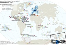 Pict. [Mapporn] Geographic extent of Adena and Hopewell mound building cultures, 1500 BC - 400 AD. Ohio and Mississippi River basins, (#River #Building #Geographic #Ohio #Cultures #Hopewell #Adena)Pict. 1564×2064 px
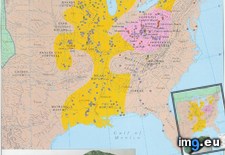 Pict. [Mapporn] The Middle East in 970 CE-AD at the greatest geographic extent of Shi'a polities. The Fatimids, Justanids, Alids, Ziya (#East #Greatest #Geographic #Fatimids #Justanids #Polities #Ziya)Pict. 1202×680 px
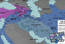 Pict. [Mapporn] Map showing the extent of the Kingdom of Armenia and the effect of the Armenian Genocide [625x473] (#Map #Showing #Kingdom #Armenian #Armenia #625x473)Pict. 625×473 px
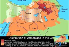 Pict. [Mapporn] Byzantine Empire at its greatest extent in 555 AD under Justinian the Great [694x396] (#Great #Greatest #Byzantine #694x396 #Justinian)Pict. 694×396 px
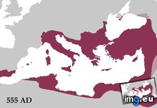 Pict. [Mapporn] Administrative districts of Poland-Lithuania at its greatest extent in 1619 [3182x2793] (#Poland #Greatest #Districts #Extent #Administrative #Lithuania)Pict. 3182×2793 px
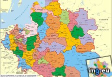 Pict. [Mapporn] Maximum Extent of Iroquois Territory During the Beaver Wars, 1638-1701 [441x443] (#Wars #Beaver #Territory #Maximum #Extent #Iroquois)Pict. 441×443 px
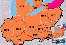 Pict. [Mapporn] The Byzantine Empire at its greatest extent [2,111x1,144] (#Greatest #Empire #Extent #Byzantine)Pict. 800×434 px
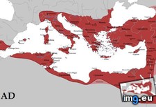 Pict. [Mapporn] Poland at its greatest extent just after the Polish Muscovite war (1605-1618)[2000x1568] (#Polish #War #Poland #Greatest #Extent)Pict. 2000×1568 px
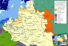 Pict. [Mapporn] The territorial extent of Great Moravia [1214x878] (#Great #Territorial #Extent)Pict. 1214×878 px
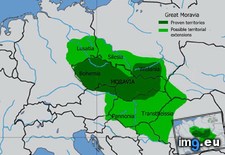 Pict. [Mapporn] The Extent of the British Empire in 1886, made by J. C. R. Colomb. [4235x3233] (#British #Empire #Extent #Colomb)Pict. 4235×3233 px
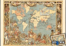 Pict. [Mapporn] Maurya Empire at its maximum extent [1500x1309] (#Empire #Maximum #Extent)Pict. 1500×1309 px
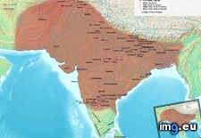 Pict. [Mapporn] Extent of Chinese Empires [1276x1000] (#Chinese #Extent #Empires)Pict. 1276×1000 px
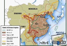
★ 9060 pts. ♥ 0 likes ⬇ 9 saves
Pict. [Mapporn] Geographic extent of Adena and Hopewell mound building cultures, 1500 BC - 400 AD. Ohio and Mississippi River basins, (#River #Building #Geographic #Ohio #Cultures #Hopewell #Adena)Pict. 1564×2064 px★ 8179 pts. ♥ 0 likes ⬇ 14 saves
Pict. [Mapporn] The Middle East in 970 CE-AD at the greatest geographic extent of Shi'a polities. The Fatimids, Justanids, Alids, Ziya (#East #Greatest #Geographic #Fatimids #Justanids #Polities #Ziya)Pict. 1202×680 px★ 7711 pts. ♥ 0 likes ⬇ 6 saves
Pict. [Mapporn] Map showing the extent of the Kingdom of Armenia and the effect of the Armenian Genocide [625x473] (#Map #Showing #Kingdom #Armenian #Armenia #625x473)Pict. 625×473 px★ 7113 pts. ♥ 0 likes ⬇ 5 saves
Pict. [Mapporn] Byzantine Empire at its greatest extent in 555 AD under Justinian the Great [694x396] (#Great #Greatest #Byzantine #694x396 #Justinian)Pict. 694×396 px★ 6839 pts. ♥ 0 likes ⬇ 8 saves
Pict. [Mapporn] Administrative districts of Poland-Lithuania at its greatest extent in 1619 [3182x2793] (#Poland #Greatest #Districts #Extent #Administrative #Lithuania)Pict. 3182×2793 px★ 6751 pts. ♥ 0 likes ⬇ 12 saves
Pict. [Mapporn] Maximum Extent of Iroquois Territory During the Beaver Wars, 1638-1701 [441x443] (#Wars #Beaver #Territory #Maximum #Extent #Iroquois)Pict. 441×443 px★ 6438 pts. ♥ 0 likes ⬇ 9 saves
Pict. [Mapporn] The Byzantine Empire at its greatest extent [2,111x1,144] (#Greatest #Empire #Extent #Byzantine)Pict. 800×434 px★ 5358 pts. ♥ 0 likes ⬇ 12 saves
Pict. [Mapporn] Poland at its greatest extent just after the Polish Muscovite war (1605-1618)[2000x1568] (#Polish #War #Poland #Greatest #Extent)Pict. 2000×1568 px★ 5233 pts. ♥ 0 likes ⬇ 12 saves
Pict. [Mapporn] The territorial extent of Great Moravia [1214x878] (#Great #Territorial #Extent)Pict. 1214×878 px★ 5104 pts. ♥ 0 likes ⬇ 8 saves
Pict. [Mapporn] The Extent of the British Empire in 1886, made by J. C. R. Colomb. [4235x3233] (#British #Empire #Extent #Colomb)Pict. 4235×3233 px★ 5101 pts. ♥ 0 likes ⬇ 7 saves
Pict. [Mapporn] Maurya Empire at its maximum extent [1500x1309] (#Empire #Maximum #Extent)Pict. 1500×1309 px★ 4802 pts. ♥ 0 likes ⬇ 5 saves
Pict. [Mapporn] Extent of Chinese Empires [1276x1000] (#Chinese #Extent #Empires)Pict. 1276×1000 px★ 4718 pts. ♥ 0 likes ⬇ 3 saves