Pict. [Mapporn] The United States' largest 53 metro areas Voronoi diagram - Taxicab geometry edition [OC] [1429x803] (#States #Edition #United #Diagram #Geometry #Voronoi #Taxicab)Pict. 1429×803 px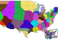 Pict. [Mapporn] Voronoi Map of National Parks: the USA divided into regions based on which national park is closest [2673x2095] [OC] (#Park #Map #National #Closest #Divided #Parks #Voronoi)Pict. 2673×2095 px
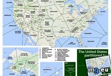 Pict. [Mapporn] Voronoi map of Canadian capitals overlaid on existing borders [1600x1125] (#Map #Canadian #Borders #Capitals #Overlaid #Voronoi)Pict. 1600×1125 px
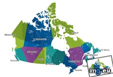 Pict. [Mapporn] Voronoi Map of Closest International Airport to any Point on the Globe [2038x1014] (#Map #Point #Globe #Closest #Voronoi)Pict. 2038×1014 px
 Pict. [Mapporn] Which Country is the Closest to You? - a Voronoi diagram-based map of the US [3234x1406] (#Map #Country #Based #Closest #Diagram #Voronoi)Pict. 3234×1406 px
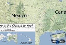 Pict. [Mapporn] Voronoi map world capitals [1083x3981] (#World #Map #Capitals #Voronoi)Pict. 1083×3981 px
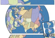 Pict. [Mapporn] World Airports Voronoi [679x656] (#World #Voronoi )Pict. 679×656 px
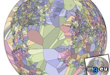
★ 7610 pts. ♥ 0 likes ⬇ 8 saves
Pict. [Mapporn] Voronoi Map of National Parks: the USA divided into regions based on which national park is closest [2673x2095] [OC] (#Park #Map #National #Closest #Divided #Parks #Voronoi)Pict. 2673×2095 px★ 7306 pts. ♥ 0 likes ⬇ 6 saves
Pict. [Mapporn] Voronoi map of Canadian capitals overlaid on existing borders [1600x1125] (#Map #Canadian #Borders #Capitals #Overlaid #Voronoi)Pict. 1600×1125 px★ 7002 pts. ♥ 0 likes ⬇ 10 saves
Pict. [Mapporn] Voronoi Map of Closest International Airport to any Point on the Globe [2038x1014] (#Map #Point #Globe #Closest #Voronoi)Pict. 2038×1014 px★ 6622 pts. ♥ 0 likes ⬇ 8 saves
Pict. [Mapporn] Which Country is the Closest to You? - a Voronoi diagram-based map of the US [3234x1406] (#Map #Country #Based #Closest #Diagram #Voronoi)Pict. 3234×1406 px★ 5757 pts. ♥ 0 likes ⬇ 3 saves
Pict. [Mapporn] Voronoi map world capitals [1083x3981] (#World #Map #Capitals #Voronoi)Pict. 1083×3981 px★ 5197 pts. ♥ 0 likes ⬇ 10 saves
Pict. [Mapporn] World Airports Voronoi [679x656] (#World #Voronoi )Pict. 679×656 px★ 3994 pts. ♥ 0 likes ⬇ 1 saves