★ 9108 pts. ♥ 0 likes ⬇ 20 saves
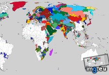
 Pict. [Mapporn] World Map With Lines Joining Constituent Countries, Overseas Departments, and Non-Contiguous States and Territories to (#World #Map #Non #Lines #Contiguous #Territories #Departments #Constituent)Pict. 2638×1196 px
★ 9083 pts. ♥ 0 likes ⬇ 15 saves
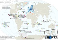
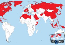
 Pict. [Mapporn] World Map showing the full extent of the European Union (including its Outermost Regions), its Overseas Countries and (#World #Map #Full #Showing #Including #Overseas #Extent #Outermost)Pict. 2206×1358 px
★ 9060 pts. ♥ 0 likes ⬇ 9 saves
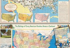
 Pict. [Pics] This map has hung in my firehouse for years. I just looked at it for the first time. (#Time #Years #Map #Looked #Hung)Pict. 2448×3264 px
★ 9037 pts. ♥ 0 likes ⬇ 11 saves
 Pict. [Mapporn] 1752, Joseph Nicolas Delisle and Philippe Buache. Carte des Nouvelles Decouvertes. Interesting map of the world I foun (#World #Map #Interesting #Des #Buache #Decouvertes #Delisle #Foun #Nouvelles)Pict. 1937×1375 px
★ 8852 pts. ♥ 0 likes ⬇ 18 saves
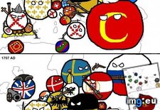
 Pict. Europe history (Polandball meme style flags maps) (#Map #Europe #Meme #Maps #Poland #Flags #Polandball)Pict. 560×6186 px
★ 8553 pts. ♥ 0 likes ⬇ 9 saves
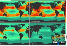
 Pict. [Mapporn] Predictive density map of an estimated 5 trillion plastic pieces polluting the world's oceans, split into 4 size categ (#World #Map #Size #Density #Oceans #Trillion #Categ #Polluting #Predictive)Pict. 1885×1081 px
★ 8540 pts. ♥ 0 likes ⬇ 12 saves
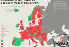
 Pict. [Mapporn] Map of the European Economic Area (+Croatia) showing EEA Migration Percentages and Origins of the Largest EEA Migrant (#Map #Showing #European #Area #Eea #Migration #Percentages #Migrant)Pict. 1380×1040 px
★ 8469 pts. ♥ 0 likes ⬇ 16 saves
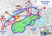
 Pict. [Mapporn] A map of Operation Tannenbaum: Hitler's planned - but ultimately cancelled - invasion of Switzerland during WWII [1024 (#Map #Hitler #Switzerland #Invasion #Cancelled #Ultimately #Tannenbaum)Pict. 1024×666 px
★ 8460 pts. ♥ 0 likes ⬇ 14 saves
 Pict. [Mapporn] USSR (Russia) plans to nuke Denmark (5 bombs) in a Cold War era Warsaw Pact attack plan 'Seven days to Paris' [2816x21 (#Map #Europe #Paris #Cold #War #Era #Plans #Bombs #Nuke #Warsaw)Pict. 2816×2112 px
★ 8448 pts. ♥ 0 likes ⬇ 8 saves
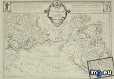
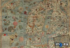
 Pict. mapporn-carta-marina-the-earliest-somewhat-accurate-map-of-the-north-2006-1486 (#White #Map #Wide #Europe #North #Marina #Stats #Statistics #Carta #Earliest)Pict. 2006×1486 px
★ 8371 pts. ♥ 0 likes ⬇ 2 saves
 Pict. [Mapporn] The largest map in the world? 700m x 900m topographical map of Aksai Chin in Ningxia Provence, China (details in comme (#World #Map #China #Largest #Topographical #700m #900m #Aksai #Ningxia)Pict. 1560×968 px
★ 8365 pts. ♥ 0 likes ⬇ 15 saves
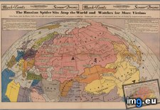
 Pict. [Mapporn] The Russian Spider sits atop the World and Watches for More Victims. Colored full spread newspaper map published in th (#World #Map #Full #Spread #Newspaper #Watches #Victims #Published #Atop)Pict. 3000×1949 px
★ 8349 pts. ♥ 0 likes ⬇ 5 saves
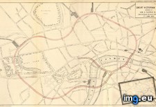
 Pict. [Mapporn] Map of the Great Victorian Way, a proposed loop around central London composed of glass-roofed streets, shops and rail (#Great #Map #Way #London #Rail #Victorian #Proposed #Loop #Roofed)Pict. 957×600 px
★ 8321 pts. ♥ 0 likes ⬇ 9 saves
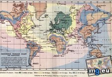
 Pict. [Mapporn] Isochronic Passage Chart for Travelers (global map of travel time departing from London) Francis Galton, 1881. [1145×7 (#Time #Map #London #Travel #Travelers #Departing #Galton #Isochronic)Pict. 1145×749 px
★ 8285 pts. ♥ 0 likes ⬇ 14 saves
 Pict. [Mapporn] [OC] My map project: Every ethno-linguistic group gets a nation! based primarily on language-speaker distribution but (#Map #Group #Project #Distribution #Ethno #Primarily #Speaker)Pict. 5147×2225 px
★ 8274 pts. ♥ 0 likes ⬇ 6 saves
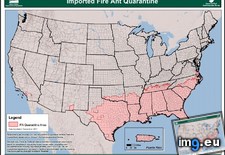
 Pict. [Mapporn] USDA map showing quarantine zones for red imported fire ants (S. invicta) in the United States [871x675] (#Map #Red #Showing #States #Imported #Quarantine #Usda #871x675 #Invicta)Pict. 871×675 px
★ 8250 pts. ♥ 0 likes ⬇ 8 saves
 Pict. [Mapporn] Map of countries the United States have fought in or occupied. Excludes airstrikes and special forces operations. [450 (#Map #States #Countries #Special #Operations #Airstrikes #Excludes)Pict. 4500×2234 px
★ 8234 pts. ♥ 0 likes ⬇ 7 saves
 Pict. [Mapporn] A Pictorial Map of the United States of America: Showing Principal Regional Resources, Products and Natural Features. (#Map #Showing #Natural #Regional #Features #Principal #Products)Pict. 1800×2715 px
★ 8139 pts. ♥ 0 likes ⬇ 8 saves
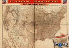
 Pict. [Mapporn] 'A correct map of the United States showing the Union Pacific, the overland route and connections' Published in 1892 [ (#Map #Showing #States #United #Correct #Connections #Overland)Pict. 2092×1535 px
★ 8059 pts. ♥ 0 likes ⬇ 5 saves
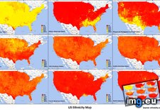
 Pict. [Mapporn] The same USA 'Voter Ethnicity' map, presented as county data rather than as a population density map (as per a convers (#Map #Population #County #Usa #Presented #Ethnicity #Convers)Pict. 3979×2262 px
★ 8032 pts. ♥ 0 likes ⬇ 6 saves
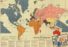
 Pict. [Mapporn] Infamous map of the 'Post-War New World Moral Order' constructed shortly before Pearl Harbour by Maurice Gomberg [3972 (#World #Map #War #Order #Moral #Shortly #Maurice #Gomberg)Pict. 2383×1699 px
★ 8003 pts. ♥ 0 likes ⬇ 5 saves
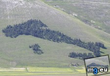
 Pict. [Mapporn] Arboreal map of Italy, Sicily and Sardinia: a pine grove in Castelluccio di Norcia, Apennine Mountains. [990×743] (#Map #Mountains #Italy #Grove #Arboreal #Castelluccio #Norcia)Pict. 990×743 px
★ 7987 pts. ♥ 0 likes ⬇ 4 saves
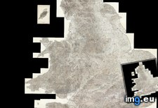
 Pict. [Mapporn] Composite map of England in 1900 made with 360 seperate maps. (Extremely high resolution zoomable source in comments, (#High #Source #Map #Extremely #Composite #Zoomable #Seperate)Pict. 5786×6600 px
★ 7906 pts. ♥ 0 likes ⬇ 7 saves