Pict. [Mapporn] New Jersey has some nice lines. Geological map of New Jersey made by Henry Rodgers in 1839 [3038x5365] (#Nice #Map #Henry #Geological #Rodgers)Pict. 3038×5365 px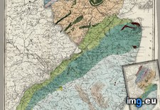 Pict. [Mapporn] Composite map of England in 1900 made with 360 seperate maps. (Extremely high resolution zoomable source in comments, (#High #Source #Map #Extremely #Composite #Zoomable #Seperate)Pict. 5786×6600 px
 Pict. [Mapporn] Early map of Kingdom of Serbs, Croats and Slovenes (Yugoslavia) [3286x3424] (#Map #Early #Kingdom #Yugoslavia)Pict. 3286×3424 px
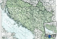 Pict. [Mapporn] A Japanese map of China made in 1909 by K. Sato [4556x3269] (#Japanese #Map #China #Sato)Pict. 4556×3269 px
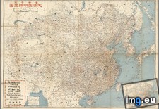 Pict. [Mapporn] The Voyage of the Pequod from the Book Moby Dick by Herman Melville. Map created by Everett Henry in 1956 [5118x3776] (#Dick #Map #Book #Created #Everett #Melville #Pequod)Pict. 5118×3776 px
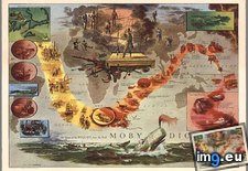 Pict. [Mapporn] Australian national public transport map (Warning: huge image) [8440x9615] (#Image #Huge #Map #Australian #Transport #8440x9615)Pict. 8440×9615 px
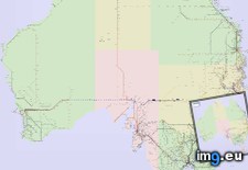 Pict. [Mapporn] 'Moral & Political map of the World', made in 1821 by William C. Woodbridge [5540x3436] (#World #Map #Political #Moral #Woodbridge)Pict. 5540×3436 px
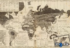 Pict. [Mapporn] Johann Homann's map of Scandinavia and the Baltic Sea, ca 1715 [5000x4285] (#Map #Sea #Johann #Baltic)Pict. 3500×3000 px
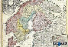 Pict. [Mapporn] Pictorial map of Silicon Valley in 1991, made by FAP [3801x5541] (#Map #Valley #Fap)Pict. 3801×5541 px
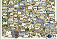 Pict. [Mapporn] John Rocque’s Map of London originally made in 1746 (Copy made in 1919) [4844x2601] (#Map #London #John #Originally)Pict. 4844×2601 px
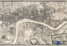 Pict. [Mapporn] Giant precinct-level map of the results of the U.S. Presidential Election 2008 [creator: Stephen Wolf] [10555x5788] (#Map #Giant #Wolf #Presidential #Stephen)Pict. 10555×5788 px
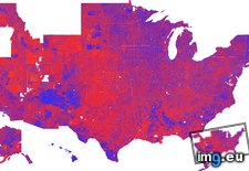 Pict. [Mapporn] Geological map of Europe, made by Andre Dumont in 1875 [5132x4409] (#Map #Europe #Andre #Geological #Dumont)Pict. 5132×4409 px
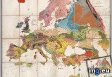 Pict. [Mapporn] Chinese World map, 1648, By Francesco Sanbiasi [8682x6269] (#World #Map #Chinese #Francesco #8682x6269 #Sanbiasi)Pict. 5209×3761 px
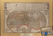 Pict. [Mapporn] Map of an exploring expedition to the Rocky Mountains in the year 1842 and to Oregon & north California in the yea (#Year #Map #California #Rocky #Exploring #Yea #Expedition)Pict. 9000×5313 px
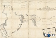 Pict. [Mapporn] Navy war map No.1: the Mediterranean. Made by the US Navy Educational Services Division in 1944 (Map No.2: South China (#Map #South #War #Division #Mediterranean #Educational)Pict. 5926×4034 px
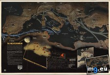 Pict. [Mapporn] Japanese World Map from the Board Game 'Conquering the Skies'. Made in 1930 [5291x3834] (#Japanese #Game #Board #Skies #Conquering)Pict. 5291×3834 px
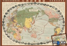 Pict. [Mapporn] A map of the 1792 Mysore Division [3600x4337] (#Map #Division #Mysore)Pict. 3600×4337 px
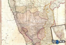 Pict. [Mapporn] A map of Chicago's Gangland (1981). 'Designed to inculcate the most important principles of piety and virtue in young (#Young #Map #Chicago #Principles #Inculcate #Piety #Virtue)Pict. 4554×3665 px
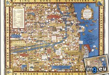 Pict. [Mapporn] 2015 Population Map 4th Edition (the old version was deleted due to improper citation) [7088x3008] (#Old #Map #Edition #4th #Due)Pict. 7088×3008 px
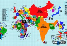 Pict. [Mapporn] Population Map 2015 3rd Edition + 4 Bonus Maps [7088x3008] (#3rd #Map #Population #Edition #Bonus #Maps)Pict. 7088×3008 px
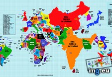 Pict. [Mapporn] The first Buddhist world map printed in Japan and the prototype for all subsequent Buddhist world maps printed in Japa (#World #Map #Japan #Prototype #Japa #Subsequent)Pict. 4284×3512 px
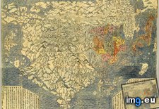 Pict. [Mapporn] Japan the Target, a pictorial map made by Ernest Dudley Chase, 1942 [4003x5830] (#Map #Japan #Ernest #Pictorial #Dudley)Pict. 4003×5830 px
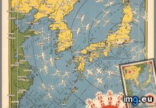 Pict. [Mapporn] Revised 2015 World Population Map[7088x3008] (#World #Map #Population #Revised)Pict. 7088×3008 px
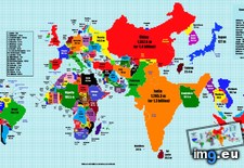 Pict. [Mapporn] The Railway Map of South Africa (from 1912) [3568x3914] (#Map #South #Africa #Railway)Pict. 3568×3914 px
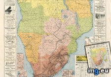
★ 5818 pts. ♥ 0 likes ⬇ 4 saves
Pict. [Mapporn] Composite map of England in 1900 made with 360 seperate maps. (Extremely high resolution zoomable source in comments, (#High #Source #Map #Extremely #Composite #Zoomable #Seperate)Pict. 5786×6600 px★ 7906 pts. ♥ 0 likes ⬇ 7 saves
Pict. [Mapporn] Early map of Kingdom of Serbs, Croats and Slovenes (Yugoslavia) [3286x3424] (#Map #Early #Kingdom #Yugoslavia)Pict. 3286×3424 px★ 5113 pts. ♥ 0 likes ⬇ 4 saves
Pict. [Mapporn] A Japanese map of China made in 1909 by K. Sato [4556x3269] (#Japanese #Map #China #Sato)Pict. 4556×3269 px★ 4890 pts. ♥ 0 likes ⬇ 5 saves
Pict. [Mapporn] The Voyage of the Pequod from the Book Moby Dick by Herman Melville. Map created by Everett Henry in 1956 [5118x3776] (#Dick #Map #Book #Created #Everett #Melville #Pequod)Pict. 5118×3776 px★ 7687 pts. ♥ 0 likes ⬇ 10 saves
Pict. [Mapporn] Australian national public transport map (Warning: huge image) [8440x9615] (#Image #Huge #Map #Australian #Transport #8440x9615)Pict. 8440×9615 px★ 7398 pts. ♥ 0 likes ⬇ 9 saves
Pict. [Mapporn] 'Moral & Political map of the World', made in 1821 by William C. Woodbridge [5540x3436] (#World #Map #Political #Moral #Woodbridge)Pict. 5540×3436 px★ 5595 pts. ♥ 0 likes ⬇ 6 saves
Pict. [Mapporn] Johann Homann's map of Scandinavia and the Baltic Sea, ca 1715 [5000x4285] (#Map #Sea #Johann #Baltic)Pict. 3500×3000 px★ 4765 pts. ♥ 0 likes ⬇ 5 saves
Pict. [Mapporn] Pictorial map of Silicon Valley in 1991, made by FAP [3801x5541] (#Map #Valley #Fap)Pict. 3801×5541 px★ 4485 pts. ♥ 0 likes ⬇ 7 saves
Pict. [Mapporn] John Rocque’s Map of London originally made in 1746 (Copy made in 1919) [4844x2601] (#Map #London #John #Originally)Pict. 4844×2601 px★ 5224 pts. ♥ 0 likes ⬇ 5 saves
Pict. [Mapporn] Giant precinct-level map of the results of the U.S. Presidential Election 2008 [creator: Stephen Wolf] [10555x5788] (#Map #Giant #Wolf #Presidential #Stephen)Pict. 10555×5788 px★ 6537 pts. ♥ 0 likes ⬇ 3 saves
Pict. [Mapporn] Geological map of Europe, made by Andre Dumont in 1875 [5132x4409] (#Map #Europe #Andre #Geological #Dumont)Pict. 5132×4409 px★ 5868 pts. ♥ 0 likes ⬇ 9 saves
Pict. [Mapporn] Chinese World map, 1648, By Francesco Sanbiasi [8682x6269] (#World #Map #Chinese #Francesco #8682x6269 #Sanbiasi)Pict. 5209×3761 px★ 5988 pts. ♥ 0 likes ⬇ 2 saves
Pict. [Mapporn] Map of an exploring expedition to the Rocky Mountains in the year 1842 and to Oregon & north California in the yea (#Year #Map #California #Rocky #Exploring #Yea #Expedition)Pict. 9000×5313 px★ 7348 pts. ♥ 0 likes ⬇ 13 saves
Pict. [Mapporn] Navy war map No.1: the Mediterranean. Made by the US Navy Educational Services Division in 1944 (Map No.2: South China (#Map #South #War #Division #Mediterranean #Educational)Pict. 5926×4034 px★ 7286 pts. ♥ 0 likes ⬇ 6 saves
Pict. [Mapporn] Japanese World Map from the Board Game 'Conquering the Skies'. Made in 1930 [5291x3834] (#Japanese #Game #Board #Skies #Conquering)Pict. 5291×3834 px★ 6621 pts. ♥ 0 likes ⬇ 9 saves
Pict. [Mapporn] A map of the 1792 Mysore Division [3600x4337] (#Map #Division #Mysore)Pict. 3600×4337 px★ 4349 pts. ♥ 0 likes ⬇ 2 saves
Pict. [Mapporn] A map of Chicago's Gangland (1981). 'Designed to inculcate the most important principles of piety and virtue in young (#Young #Map #Chicago #Principles #Inculcate #Piety #Virtue)Pict. 4554×3665 px★ 7997 pts. ♥ 0 likes ⬇ 16 saves
Pict. [Mapporn] 2015 Population Map 4th Edition (the old version was deleted due to improper citation) [7088x3008] (#Old #Map #Edition #4th #Due)Pict. 7088×3008 px★ 5587 pts. ♥ 0 likes ⬇ 3 saves
Pict. [Mapporn] Population Map 2015 3rd Edition + 4 Bonus Maps [7088x3008] (#3rd #Map #Population #Edition #Bonus #Maps)Pict. 7088×3008 px★ 5509 pts. ♥ 0 likes ⬇ 3 saves
Pict. [Mapporn] The first Buddhist world map printed in Japan and the prototype for all subsequent Buddhist world maps printed in Japa (#World #Map #Japan #Prototype #Japa #Subsequent)Pict. 4284×3512 px★ 7036 pts. ♥ 0 likes ⬇ 6 saves
Pict. [Mapporn] Japan the Target, a pictorial map made by Ernest Dudley Chase, 1942 [4003x5830] (#Map #Japan #Ernest #Pictorial #Dudley)Pict. 4003×5830 px★ 6009 pts. ♥ 0 likes ⬇ 14 saves
Pict. [Mapporn] Revised 2015 World Population Map[7088x3008] (#World #Map #Population #Revised)Pict. 7088×3008 px★ 4931 pts. ♥ 0 likes ⬇ 5 saves
Pict. [Mapporn] The Railway Map of South Africa (from 1912) [3568x3914] (#Map #South #Africa #Railway)Pict. 3568×3914 px★ 4978 pts. ♥ 0 likes ⬇ 7 saves